Modelling coseismic landslide impacts on infrastructure systems in Wellington
NZGS Research Scholarship
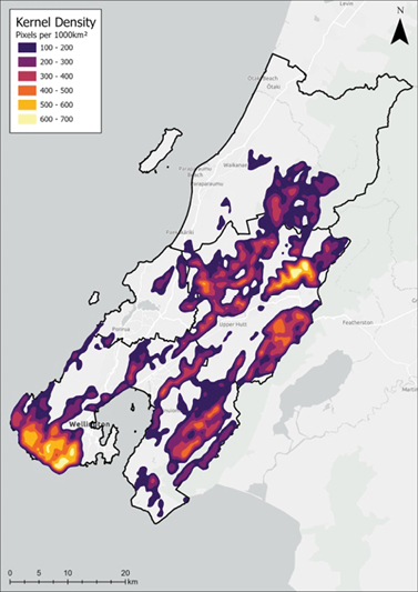
A rupture of the Wellington Fault is widely considered to be the greatest seismic risk to Aotearoa. A MW 7.5 earthquake has been posited on the Wellington-Hutt Valley segment of the fault, with an estimated probability of 10-15% occurrence in the next century and potential shaking intensities exceeding MM 10 in Wellington’s city centre. Despite coseismic landslides having occurred in previous large earthquakes in this region, the hazard posed in such a scenario has yet to be assessed. This project seeks to model coseismic landsliding susceptibility for a MW 7.5 Wellington Fault rupture, estimating plausible runout pathways of potential landslides. Further, this research assesses the extent of built infrastructure situated within predicted runout pathways, to ascertain the potential impacts of coseismic landsliding in this urban environment. The objectives of this project will be met using statistical landslide models, to assess the relationship between ground motion and various topographic conditioning factors to forecast landslide hazard. Preliminary analysis was carried out by Harvey (2022) (Figure 1 and 2), using a fuzzy logic to assess landslide hazard across the Wellington Region; however, this research did not distinguish between natural and anthropogenic slopes.

Figure 1. Coseismic landslide susceptibility of research area, as determined by fuzzy membership (Harvey, 2022).

Figure 2. Kernel density map of highest 10% of landslide susceptibility values, that is > 0.933 (Harvey, 2022).
The current research will implement approaches from the SLIDE project in addition to fuzzy logic modelling, to identify the most appropriate approach for the highly modified slopes of the Wellington Region. Key outputs of this analysis will offer an updated approach to assessing coseismic landslide susceptibility in the New Zealand context. Output of landslide hazard modelling will be utilised to estimate runout of areas susceptible to landsliding in a Wellington Fault Rupture Scenario, followed by identification of infrastructure systems potentially affected both by slope failure and runout. The potential impacts of coseismic landslides on infrastructure systems will then be assessed, to estimate outage and potential restoration times of critical infrastructure systems in the given scenario. Outputs of this analysis will provide the opportunity to posit mitigation strategies to reduce the impact of a Wellington Fault rupture event on infrastructure in the Wellington Region.
